Alamo Archaeology
Southwest & Northwest Wall
Gun Emplacements
by Jake Ivey
The west wall of the Alamo was
laid out in about 1750-1760. At that time the entire complex consisted of
five sets of three rooms, each room about 22 feet long on the inside (See
Figure 1). The southernmost set of three rooms were made of adobe;
the next set was probably also adobe, and the northern three were probably
of stone. Each set of rooms had a row of three arches in front, facing into
the plaza. In 1772 these rooms are described as having a door facing east
(into the plaza) and a window facing west, through the outer wall.l
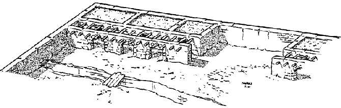
Figure 1. Circa 1760 --Southwest
corner of west wall of Alamo soon after construction.
These rooms deteriorated through the last quarter of the eighteenth century,
until by 1800 most were in ruin, and one adobe building had apparently collapsed.
When the Compañía Volante del Alamo arrived in [1803], these rooms
required considerable work before they were useable and were never acceptable
to the troops.
(See Figure 2)See Also:
Floor plan
The Compañía Volante was moved out of the Alamo in about [1830,
but returned in late 1832. Most of the surviving structures were sold during
this period]. See Also: The
Second Flying Company of Alamo de Parras
By 1829 the adobe room in the southwestern corner still stood, but the next
two rooms north were probably useless ruins. The next block of three adobe rooms
was apparently gone without a trace, and the three stone blocks of rooms were
in various states of poor repair. The southwestern corner room belonged to the
Losoya family. The next 264 feet of wall, including a set of stone rooms towards
the north end, belonged to the family of Alexandro Treviño, captain of
the Presidial Company of Bexar. In the area of the rooms, the walls stood to
a height of 12 1/2
feet, while the wall from the rooms south to Losoya's southwestern corner room
was only about 7 feet high.2 The remainder
of the west wall to the northwest corner belonged to Francisco Castañeda.
He was an officer of the Compañía Volante who was directly involved
in the Texas Revolution, since he was the commander of the Mexican troops who
attempted to seize the cannon from the Anglo colonists at Gonzales. Castañeda's
property was later bought from his widow by Samuel Maverick, and the Maverick
family lived in one of the two stone blocks of houses on this portion of the
wall.3
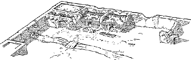
Figure 2. Circa 1810-- Southwest corner
in use as barracks for Compañía Volante del Alamo (Flying Company)
Fortification
When the fortification of the Alamo was begun in October of 1835, gun platforms
were built into the northwestern and southwestern corners of the west wall.
In the southwestern corner, the Losoya adobe still stood to a height of 9
feet, with unusable ruins all that remained of the two rooms north of it.
A fragment of the front archway survived. The military engineers added a section
of wall or palisade to make the Losoya house and front archway into a square
retaining wall about 25 feet square. They filled this with earth up to about
3 feet below the top of the outside wall, and built a wooden floor on this
packed earth surface. Adding a ramp 9 feet wide and about 37 feet long completed
the southwestern gun platform, where later the Texans would place the l8-pounder
firing in barbette over the wall top (Figure 3)
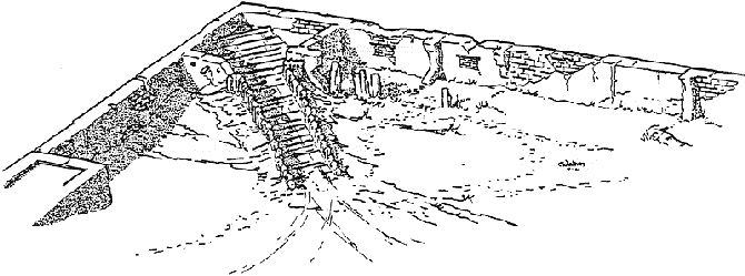
Figure 3. 1836--
Southwest corner cannon emplacement during battle.
The old acequia opening and the windows in west wall are bricked up.
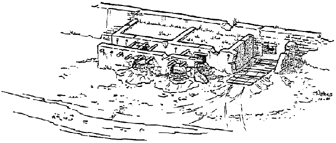
In the northwestern corner, the room and archway were again filled, but since
the wall stood to a height of 12 feet, it was decided to have the cannon placed
here firing through embrasures.4 This gives greater cover to the gunners but
limits the field of fire. The platform here was probably about 8 feet above
the grout ant had a 48 foot ramp (Figure 4). Apparently
the next room south remained in sufficiently good condition to be used ant
was mate into officer's quarters. Some rooms in the next block to the south
were also in a repairable condition and were also made into officer' quarters.
In the third block, the useable rooms were made into the Artillery Commander's
office. The fourth block, of adobe, had apparently long since disappeared.
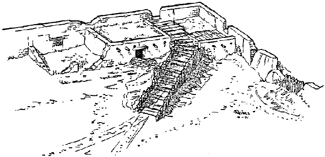
Figure 4. 1836 --Northwest corner
emplacement.
Other guns were placed along the west wall, but their positions are in doubt.
La Bastida places two guns, one on either side of the second block of rooms
at ground level firing through ports in the west wall. The surviving documents
of Green Jameson mention guns firing through ports, although Jameson toes
not mention the number of cannon (See Figure 5).
The "Jameson map" cannot e used as evidence one way or another since
it is probably a composite map drawn in 1910 Y Adina de Zavala and Charles
Merritt Barnes.
| Figure
5. 1836-- One of the two guns
firing through ports in the west wall. These may have been built to fire
through window openings in the west wall; left after the rooms for which
they were built had fallen. Platforms would have been built at ground
surface and as small a hole as possible made through the old window openings.
These platforms would have been about 10-15 feet wide and about 20 feet
long. |
The construction of these gun platforms in the northwest and southwest corners
was probably quite simple. Materials used would have depended on what was
most readily available. Rubble stone, adobe brick, cedar posts, brushwood
bundles called fascines, cut lumber- any of these things, or any combination,
could have been used. Wheeler in The Elements of Field Fortification, describes
the rules of construction of the various sorts of gun platforms (pages 115-125).5
Barbette fire is over the parapet. Wheeler says that the general rule is that
the surface of the platform should be 33 inches below the top of the parapet.
Each gun required a platform at least 10 feet wide at the front, and about
20 feet long. Wheeler indicated that as a rule 15 feet of front is allowed
per gun. For a barbette in a wall corner, Wheeler diagrams a gun platform
25 feet square.
Ramps should be at least 9 feet wide and sufficiently solid to
support the weight of the gun, carriage, and crew hauling it to the top. The
slope of the ramp should be not much steeper than 1:6 or six feet of length
of the ramp per foot of height. To add more slope would make the job of moving
the cannon up and down the ramp slower and more dangerous than necessary.
The top surface of the gun platform should be covered with boards or
timbers because otherwise the wheels of the gun carriage quickly wear ruts
in the earth, which lowers the gun and can damage or dismount the gun by
forcing the carriage to absorb the force of the discharge, rather than
dissipating this force through recoil.
Embrasure fire requires a platform identical in size and construction
to that for a barbette, except that the top surface of the platform can
be more than 33 inches below the top edge of the parapet. A notch called
the embrasure is cut into the parapet of the point where the cannon will
fire, sufficiently deep that the bottom of the embrasure is 33 inches above
the platform. The decision as to whether to use embrasure or barbette positions
at any given spot depends on such considerations as how wise a field of
fire is desired for the guns, how much incoming fire the gun crews will
be exposed to, how much construction time is necessary for a given plan
of platform as compared to how much time is available, and finally, what
materials are available. The choice of an embrasure position on the north
and a barbette position on the south may have been dictated almost entirely
by the heights and composition of the walls and buildings in each area,
all else being equal.
Much of this is, of course, speculation. As the several reports describing
our research and excavations of the Alamo are finished up over the next
six months, details may change. Some conclusions may develop enough archaeological
support to become "highly probable." The general outline of the results,
however, will probably remain about as described here.
–Jake Ivey, Archaeological Assistant UTSA, 1981.
This Article orignially appeared
in the A.L.A. M.O. Newsletter.
© Copyright 1981, Jake Ivey. Used
with permission. Illustrations by Mikc Waters, 1981. Corrections in Brackets
mine.
Sources:
1. Texas Historical Commission, Inventory of the Mission
San Antonio de Valero: 1772, Office of the State Archaeologist, Special
Report 23, Austin, Texas, p. 25.
2. Bexar County Deed Records, Vol. Fl, Spanish Government
to Captain Alexandro Treviño, pp. 206-208.
3. Green, Rena Maverick, Samuel Maverick, Texan, 1952.
4. La Bastida Map, Barker Archives Map Collection.
5. Wheeler, J. B., The Elements of Field Fortifications
(New York: Van Nostrand Co., 1898).