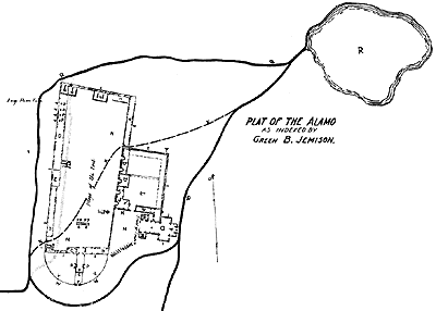
Plat of the Alamo fortifications
in 1836. Copy of Green B. Jameson's map.
[click to enlarge
(92k) 800 x 571]
This sketch is several generations removed from Green B. Jameson's originals, which have not been located. It shows some preparations, such as the works below the south walls, that were probably never completed, only contemplated. The course of the acequia(irrigation ditch) through the main plaza does not agree with other renditions. Jameson sent one plat to Houston and another to Smith, showing the Alamo as it was when taken by thc Texans and indicating (in red ink) what had been done since.
These plats are reportcd to have passed through the hands of Henderson K. Yoakum, Peter W. Gray, Mary Jane Briscoe, and Henry A. McArdle, none of whom clearly transcribed the differences that Jameson had designated.
Source: Schoelwer, Susan Prendergast, Alamo Images Changing
Perceptions of a Texas Experience,Citing--De Zavala, History
and Legends, 1917. DeGolyer Library
![]()