The initial success of any new mission was dependent upon the planting and harvesting of crops. Sparse rainfall and the need for irrigation water made the design and installation of an acequia system a high priority. So important was irrigation in Spanish Texas that cropland was measured in suertes, the amount of land that could be watered in one day
The Moslems introduced use of acequias (irrigation ditches) to the arid regions of Spain. Once arrived on the frontier, the Franciscans found the system well suited for use in the desert Southwest. In order to distribute the water, missionaries and Indians built seven gravity-flow ditches, five dams and an aqueduct – a 15 mile network that irrigated about 3,500 acres of land.
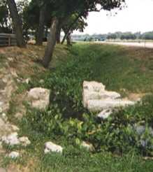
The best preserved of the San Antonio acequias is the one near Mission Espada.
Espada Dam, completed by 1740. It diverted river water into an acequia madre
(mother ditch). It is still in operation, but now plays a secondary role beside
the modern dam. The water was carried over Piedras Creek through the Espada
Aqueduct – one of the oldest arched Spanish aqueducts in the United States.
Using floodgates, the aguador (water master) controlled the volume of water
sent to each field for irrigation and for such auxiliary uses as bathing,
washing, and power for mill wheels. Today, nearby farms still use the water
from this system.
The Alamo Acequia
Construction of the acequia at Mission San Antonio de Valero began in 1719. The source of the acequia was the San Antonio River near the ford of the "Paso de Tejas" where water was diverted from the river by means of a diversion dam that extended into the stream from its western bank. The acequia served to raise and direct the flow of water toward the eastern bank to a canal intake. In present-day San Antonio, this point can be found in Brackenridge Park, south of the intersection of Broadway and Hildebrand near the Witte Museum.
This small channel traced a winding pathbetween the river and low hills to east. It turned toward south-southwest and passed through the mission grounds only to return to the river at the largest bend. This created a ditch approximately three and one-half miles in length. Later additions to the channel branched near the mission and irrigated additional labores (farmlands) to the east and south. This extended the total length of the acequia to approximately ten miles. The unlined ditch had a width of approximately six feet and a depth of three to four feet.
There is virtually no mention in the records of acequia relating to the battle of 1836, probably because its small size created no impediment to the advance of Mexican troops. Since the acequia was their only source of water and it could so easily be cutoff or diverted, the Texians constructed a well within the compound before hostilities began. Some accounts relate that the acequia may have been used for clandestine entries and exits during the battle.
The acequia remained in use until 1912. After this time, the city filled and generally forgot the acequia. However, in recent times renewed archaeological interest resulted in the excavations of small portions of the ditch. One such excavation was the section located behind the chapel on the grounds of the Alamo. Other portion can be seen on the grounds of the downtown Hampton Inn and in HemisFair Park.