|
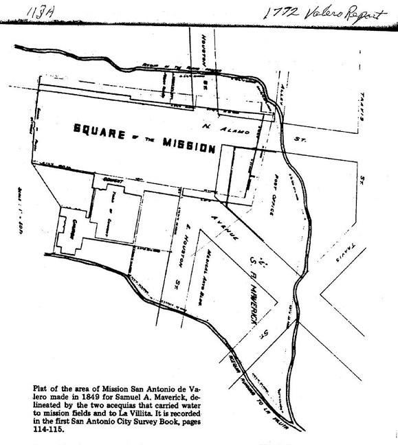
Survey for Plat and Field Notes of a Lot or Tract of land situated in the forks of the Ditch running past the Church of the Alamo to the Villita, and of that running on the West side of the Old Mission of the Alamo or San Antonio de Valero, said Lot surrounding the Northern portion of the Square or Plaza of the aforesaid Mission - surveyed for S. A. Maverick - Beginning at the N.W. corner of the Old Convent or residence of the Padres of the Mission - Thence along with wall of said building, S. 78í° E. 7.08 varas (19 ft. 8 in.) to its N.E. corner and 53 varas to a point in a line with the East wall of the Old Convent Yard which ran from the N.E. corner of the Chapel & Vestry building (on the North side of the Church) in the direction of N.E. - Thence running in a line with said old wall and towards it S. 11° W. 30˝ varas to the N.E. corner of the old Convent yard - Thence S. 78í° E., 26Ľ vas. To a stake on the Villita Ditch - Thence up said Ditch N. 46˝° E., 26˝ vas. - N 23 2/3° E. 49 vas. - N. 50Ľ° E., 84 vas. to a stake in the junction of this Ditch, and that running North and West of the buildings of the Mission - Thence down the latter ditch, N. 85° W. 19˝ vas. to a Willow - N. 81° W. 139 varas to a point in a line with East wall of the old Convent - Thence S. 75 1/8 W. 87Ľ vas. To the N.W. corner of the Muralla or outer wall of the Mission, which is about 4 vas. from the ditch - Thence keeping down the same ditch S. 64í° W. 30Ľ vas. S. 10í° W. 30 vas. & S. 2˝° W. 38 vas. to a stake on the edge of ditch - Thence with North line of a lot and house of DŞ Jesusita Treviño and passing along the North side of Chimney of said house S. 79 5/8° E., 62.80 varas, to the N.W. exterior corner of the Mission Wall or Muralla, already mentioned - Thence along North side of Said Wall S. 75 5/8° E., 57.90 vas. - Thence running across said wall (which is about 1.08 vara thick) and six varas beyond it, to cover the building site of Carmel de las Reyes S. 10° W., 7.08 vas. - Thence S. 75_° E., 20 vas. to the N.E. corner of the Mission Square - Thence along the East side of said square, S. 10° W. - 52.4 vas. to the beginning but leaving a passage 2 varas wide on the North side of the old Convent, by which access may be had to the yard on the East side of Said Convent, from the square of the Mission. San Antonio F.
Giraud, City Sr. Br. Recorded in City Survey Book, pp. 114 & 115. F. Giraud [rubric]
|